COMPOSITIONAL LAYERS OF EARTH
The chemical differentiation which
began early in the earth’s history is still occurring but on a much smaller
scale
Because of the chemical
differentiation earth’s interior is not
homogeneous
It consists of three major regions
that have different chemical compositions
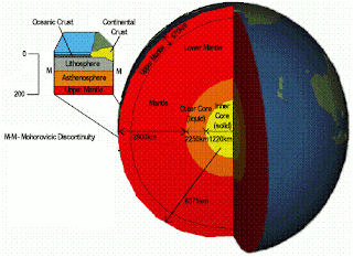
The principle division of Earth
includes:
The Crust, Earth’s
comparatively thin outer skin ranges in thickness from 3 kilometers (2 miles)
at the oceanic ridges to over 70 kilometers (40 miles) in some mountain belts
The Mantle, a solid rocky
shell that extends to a depth of about 2885 kilometers (1800 miles)
The Core, which can be further
divided into the Outer Core and Inner Core
The Outer Core, a molten
metallic layer some 2270 kilometers (1410 miles) thick
The Inner Core, a solid iron
rich sphere having a radius of 1216 kilometers (756 miles)
THE CRUST
The crust, the rigid outermost layer
of Earth is further divided into:
1. Oceanic crust
2. Continental crust
Oceanic crust range from 3 to 15
kilometers in thickness and is composed of dark igneous rocks called Basalt
The upper continental crust consists
of a large variety of rock types which have an average composition of a granitic
rock called granodiorite.
The rocks of the oceanic crust are
younger (180 million years or less) and more dense having density about 3
gm/cm3
2.7 Continental rocks have an average density
of about gm/ cm3
Some have been
discovered that exceed four billion years of
age
FEATURES OF THE OCEANIC CRUST
The three important features of the
oceanic crust are
Mid Oceanic Ridges
Oceanic Trenches
Island arcs
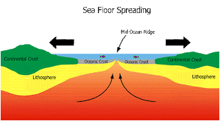
MID-OCEANIC RIDGE
A
mid-ocean ridge is a general term for an underwater mountain system that
consists of various mountain ranges (chains), typically having a valley known
as a rift running along its spine, formed by plate tectonics.
This
type of oceanic ridge is characteristic of what is known as an oceanic
spreading center, which is responsible for seafloor spreading.
The
uplifted seafloor results from convection currents which rise in the mantle as
magma at a linear weakness in the oceanic crust, and emerge as lava, creating
new crust upon cooling.
A
mid-ocean ridge demarcates/separates the boundary between two tectonic plates,
and consequently is termed a divergent plate boundary
SEA FLOOR SPREADING
Seafloor
spreading is a process that occurs at
mid-ocean ridges, where new oceanic crust is formed through volcanic activity
and then gradually moves away from the ridge.
Seafloor
spreading helps explain continental drift in the theory of plate tectonics.
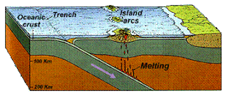
ISLAND ARCS
An
island arc is a type of archipelago composed of a chain of volcanoes
which alignment is arc-shaped, and which are situated parallel and close to a
boundary between two converging tectonic plates.
Most
of these island arcs are formed as one oceanic tectonic plate subducts
another one and, in most cases, produces magma at depth below the
over-riding plate.
OCEANIC TRENCHES
The
oceanic trenches are hemispheric-scale long but narrow topographic
depressions of the sea floor. They are also the deepest parts of the ocean
floor.
Trenches are found at the boundary between two lithospheric
plates.
There are three types of lithospheric
plate boundaries:
divergent (where lithosphere and oceanic crust is created at
mid-ocean ridges)
convergent (where one lithospheric plate sinks beneath another
and returns to the mantle)
transform (where two lithospheric plates slide past each
other).
OCEAN BASINS
The ocean basins
are known to contain the most prominent mountain ranges on Earth, the Mid
Oceanic Ridge
System
The Mid Atlantic
Ridge and East Pacific Ridge are parts of
this system
They formed a
continous belt of more than 70,000 kilometer around the globe
Rather than consisting of highly deformed
rocks the oceanic ridge system consists of layer upon layer of once molten rock
that has been fractured and uplifted
The ocean floor also contain deep graves
that are occasionally more than eleven thousand feet deep called Oceanic
Trenches
THE MANTLE
Over eighty two percent of the earth’s volume
is
contained in the
mantle
It is a rocky shell which is 2900 kilometers thick
The boundary between the crust and mantle reflects a change in
composition
The mantle behaves like a solid while transmitting
earthquake waves
Mantle rocks are
able to flow at an incredible slow rates
The mantle is
divided into the Lower Mantle or
Mesosphere which extends from the core – mantle
boundary to a
depth of 660 kilometers
The Upper
Mantle continues to the base of the crust
THE CORE
The core is composed mostly of iron with lesser amounts
of nickle and other elements
At the extreme pressure found in the
core, this iron rich
material has an average density of
about 11 gm / cm3 and have 14 times the density of water at Earth’s
centre
The inner core and outer
core are very similar
Their division is based on
differences in mechanical strength
The outer core is a liquid
capable of flow
The inner core, despite its
high temperature is stronger than the outer core and behaves like a solid.


